![]() The THEIA Land Data Centre is a French inter-agency initiative designed to promote the use of satellite data, primarily for environmental research on land surfaces but also for public policy monitoring and for management of environmental resources. Its objective is to foster the use of remote sensing data to measure the impact of human pressure and climate on ecosystems and local areas, to observe, quantify and model water and carbon cycles, to follow the evolution of societies and of their activities, including agricultural practices, and to understand the dynamics of biodiversity.
The THEIA Land Data Centre is a French inter-agency initiative designed to promote the use of satellite data, primarily for environmental research on land surfaces but also for public policy monitoring and for management of environmental resources. Its objective is to foster the use of remote sensing data to measure the impact of human pressure and climate on ecosystems and local areas, to observe, quantify and model water and carbon cycles, to follow the evolution of societies and of their activities, including agricultural practices, and to understand the dynamics of biodiversity.
Within the Land Data Centre, CNES set up a production centre named MUSCATE. This centre aims are providing users with ready-to-use products derived from time series of images acquired over large areas. Sentinel-2 will of course be the spearhead of the production centre, but before the launch of the Sentinel-2, MUSCATE will already begin to produce data from the SPOT4 (Take 5) experiment. At the same time, the processing centre also prepares the production of all Landsat data acquired over mainland France from 2009 to 2011.
MUSCATE production centre already exists in the form of a prototype developed by CNES with strong support from Cap Gemini. This prototype is already able to handle LANDSAT, SPOT, FORMOSAT-2, Sentinel-2 and Venμs data, using processors developed by CNES for geometric processing [1], and developed by CESBIO for cloud detection [2] and for atmospheric correction [3]. Simultaneously, the development of an operational production facility is being specified.
Products provided by the MUSCATE Centre are:
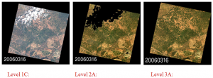
- Level 1C (orthorectified reflectance at the top of the atmosphere)
- Level 2A (ortho-rectified surface reflectance after atmospheric correction, along with a mask of clouds and their shadows, as well as a mask of water and snow).
- Level 3A (bi-monthly or monthly composite products of surface reflectances, obtained as the weighted average surface reflectance of non-cloudy pixels obtained during the period). Up to now, Level 3A chain is only available for Venμs satellite.
The data produced by MUSCATE will be freely distributed to research laboratories on the one hand, and to the French public institutions on the other, they will be if possible distributed freely to a wider community. The Land Data Center is also building a distribution server to make all these data available.
Further reading about these products :
[1]: Baillarin, S., P. Gigord, et O. Hagolle. 2008. « Automatic Registration of Optical Images, a Stake for Future Missions: Application to Ortho-Rectification, Time Series and Mosaic Products ». In Geoscience and Remote Sensing Symposium, 2008, 2:II‑1112‑II‑1115. doi:10.1109/IGARSS.2008.4779194.
[2]: Hagolle, Olivier, Mireille Huc, David Villa Pascual, et Gérard Dedieu. 2010. « A multi-temporal method for cloud detection, applied to FORMOSAT-2, VENµS, LANDSAT and SENTINEL-2 images ». Remote Sensing of Environment 114 (8) (août 16): 1747‑1755. doi:10.1016/j.rse.2010.03.002.

