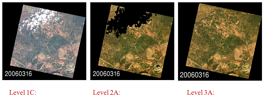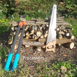
Many users are confused by the earth observation product names. Maybe detailing the logic behind  the names will help recall them. Here is how the THEIA Land Data Center product names were chosen.
- we decided to use Sentinel-2 product names 1C, 2A, 3A, since we are sure Sentinel-2 will become a reference in high resolution earth observation.
- Level 1C is a monodate ortho-rectified image expressed in TOA reflectance
- Level 2A is a monodate ortho-rectified image expressed in surface reflectance, provided with a cloud/cloud shadow/snow/water mask
- Level 3A is a monthly composite of Level2A Cloud/Cloud shadows free pixels
- this nomenclature, defined by ESA and CNES, complies with the norms of the Committee on Earth Observation Satellites (CEOS)
Let’s first recall that several Earth observing missions do not respect the CEOS norms, often because their nomenclature was defined before the norm existed. It is the case of SPOT and followers (Pleiades, Rapid Eye…)
Product Level names according to NASA
CEOS naming rules are quite difficult to find, and I had searched them several times unsuccessfully. But recently, I found the list of members of the CEOS product harmonization committee, and two of its members (Frédéric Baret (INRA, France), and Kenneth McDonald (NOAA, USA)) replied very quickly to my questions. The CEOS norm is based on a nomenclature defined by NASA in 1996, which is available on Wikipedia :
| Data Level | NASA-EOSDIS Definition |
|---|---|
| Level 0 | Reconstructed, unprocessed instrument and payload data at full resolution, with any and all communications artifacts (e.g., synchronization frames, communications headers, duplicate data) removed. |
| Level 1A | Reconstructed, unprocessed instrument data at full resolution, time-referenced, and annotated with ancillary information, including radiometric and geometric calibration coefficients and georeferencing parameters (e.g., platform ephemeris) computed and appended but not applied to Level 0 data. |
| Level 1B | Level 1A data that have been processed to sensor units (not all instruments have Level 1B source data). |
| Level 2 | Derived geophysical variables at the same resolution and location as Level 1 source data. |
| Level 3 | Variables mapped on uniform space-time grid scales, usually with some completeness and consistency. |
| Level 4 | Model output or results from analyses of lower-level data (e.g., variables derived from multiple measurements). |
Product Level names according to CEOS
I do not know what you think of it, but my sense is that it is quite vague in some aspects (what is a « sensor unit ») and too directive in some other aspects : a resampling of data on a cartographic grid is only allowed at level 3. If a uses does not want to handle the always complex reprocessing of data, he has to use the level 3 data. The CEOS norm provided below was clearly inspired by NASA’s norm, but it allows a data resampling starting at level 1, and the data can be expressed in Physical units and not only « Sensor units ». The CEOS norm does not detail the sub-levels (1A, 2B…). However, the distinction between Level 1 and Level 2 is still a bit fuzzy, as it is not always easy to tell a physical unit from a geophysical unit. We often consider a top of atmosphere reflectance as a Level 1 product and a surface reflectance after atmospheric correction a Level 2 product. Is a surface reflectance a physical unit or a geophysical unit?
| Data Level | CEOS Definition |
|---|---|
| Level 0 | Reconstructed unprocessed instrument data at full space time resolution with all available supplemental information to be used in subsequent processing (e.g., ephemeris, health and safety) appended. |
| Level 1 | Unpacked, reformatted level 0 data, with all supplemental information to be used in subsequent processing appended. Optional radiometric and geometric correction applied to produce parameters in physical units. Data generally presented as full time/space resolution. A wide variety of sub level products are possible. |
| Level 2 | Retrieved environmental variables (e.g., ocean wave height, soil moisture, ice concentration) at the same resolution and location as the level 1 source data. |
| Level 3 | Data or retrieved environmental variables which have been spatially and/or temporally re-sampled (i.e., derived from level 1 or 2 products). Such re-sampling may include averaging and compositing. |
| Level 4 | Model output or results from analyses of lower level data (i.e., variables that are not directly measured by the instruments, but are derived from these measurements). |
Product Level names according to… myself
Having had some difficulties finding the famous CEOS norm, I had build my own idea of what the CEOS norm should be, probably, from dscussions with colleagues during the POLDER.project preparation. So here is my own version of the product level names norm (but I know a personal norm is not a norm anymore)
| Data Level | Product nomenclature according to… myself |
|---|---|
| Level 0 | Reconstructed unprocessed instrument data at full space time resolution with all available supplemental information to be used in subsequent processing (e.g., ephemeris, health and safety) appended. |
| Level 1 | All pixels were acquired at the same time (within a few instants, during one satellite overpass), and their processing does not make assumptions on the nature of the observed pixel. Each pixel is processed in the same way, whatever it is made of (cloud, forest, sea…). The values are expressed in physical units or the product provides all the necessary information to convert the values to physical units. The product may be resampled onto a cartographic grid, or may just provide the necessary information to resample it. |
| Level 2 | All pixels were acquired all at the same time (within a few instants, during one satellite overpass), but here, the processing may include assumptions on the nature of the pixel, for instance concerning the atmosphere, vegetation of sea state. The pixels may be processed differently according to their nature. |
| Level 3 | The product is obtained from data acquired at different dates, often with different footprints. As for Level 2, processing may differ according to the pixel nature, and assumptions on this nature are allowed. Level 3 products are often composite products based on the level 2 data acquired during a certain period of time (10 days, one month…) |
What about the letters ?
The CEOS norm does not define sub-levels, and for that aspect, NASA’s norm has some influence. For instance, with Sentinel-2, Level 1A and Level 1B exist as internal products and are quite similar to what is in NASA norm, while the Level 1C is ortho-rectified and expressed in top of atmosphere reflectance. The level 1C only will be distributed to standard users. Sentinel-2 Mission requirement document also defines a level 2A, expressed in surface reflectance, and a Level 2B that provides biophysical variables such as LAI, fAPAR.
For product levels greater or equal to 2, we tend nowadays to follow this rule, at least in the Land community :
| Letter | Meaning |
|---|---|
| A | Level 2A and Level 3A correspond to radiative quantities : radiance, emittance, reflectance and by extension, temperature and emissivity |
| B | Level 2B and Level 3B correspond to bio or geophysical variables estimated from radiative quantities : Leaf Area Indeex, Chl content in water or leaves, fAPAR, total suspended matter, |
