![]() =>
=> ![]() Following the irrigation scheduling experiment in Morocco during the SPOT4-Take5 experiment (Le Page et al, 2014), a Web tool owing to help the irrigation decision making is under development (http://osr-cesbio.ups-tlse.fr/Satirr). The tool is functional on three Landsat8 tiles: Marrakech in Morocco, Kairouan in Tunisia, Toulouse, France. As the tool is addressing irrigators, the idea is to set an irrigated plot of the simplest and fastest possible way. After drawing his plot on a base map, the user answers to 4 questions. He chose his culture among 7 options currently parameterized (corn, wheat, olive …), its soil among the 12 USDA typical soils, the sowing date and irrigation method (flooding, sprinkler or drip). This rough initialization is adequate launch the service although, at any time, the user can change the plot contours or refine parameterization if he knows the soils, the peculiarities of its crop, etc.
Following the irrigation scheduling experiment in Morocco during the SPOT4-Take5 experiment (Le Page et al, 2014), a Web tool owing to help the irrigation decision making is under development (http://osr-cesbio.ups-tlse.fr/Satirr). The tool is functional on three Landsat8 tiles: Marrakech in Morocco, Kairouan in Tunisia, Toulouse, France. As the tool is addressing irrigators, the idea is to set an irrigated plot of the simplest and fastest possible way. After drawing his plot on a base map, the user answers to 4 questions. He chose his culture among 7 options currently parameterized (corn, wheat, olive …), its soil among the 12 USDA typical soils, the sowing date and irrigation method (flooding, sprinkler or drip). This rough initialization is adequate launch the service although, at any time, the user can change the plot contours or refine parameterization if he knows the soils, the peculiarities of its crop, etc.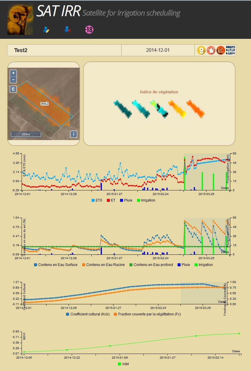
- Adaptation to Sentinel-2: the transition to S2 should not be a hassle. However, it will be necessary to adjust the calculation of the tiles to download, the download code and format reading.
- Use of Sentinel-1: In the current state, the well-performance of water balance is based on the actual information of irrigation provided by the user. We plan to test the use of S1 images to determine the irrigation dates.
- Access to local agro-weather stations: As part of the development of the Environmental Information System in Cesbio, telemetry of several weather stations has been settled up (eg, see http://trema.ucam.ac .ma) (Jarlan et al, 2015), we have to make these stations accessible through a standardized web service like Sensor Web.
- Introduction of collective irrigation network. The PhD work of Kharrou (2013) and Belaqziz (2013, 2014) have shown that remote sensing can be used to optimize water rotations of an irrigated command. We plan to offer the possibility of introducing a set of plots to associate it with a distribution network and ultimately offer an optimized arrangement of the water rotation. However, at present, this goal is more into the order of a challenge!
- We are currently working on a procedure to introduce wheat yield using remote sensing data (J. Toumi PhD Thesis) and further expect to input an early wheat yield prediction into the tool.
If you want to try it out, be my guest, it’s free. If you want to try it out on other regions, please contact me! References:
- Le Page M., J. Toumi, S. Khabba, O. Hagolle, A. Tavernier, M. Kharrou, S. Er-Raki, M. Huc, M. Kasbani, A. Moutamanni, M. Yousfi, and L. Jarlan, “A Life-Size and Near Real-Time Test of Irrigation Scheduling with a Sentinel-2 Like Time Series (SPOT4-Take5) in Morocco,” Remote Sens., vol. 6, no. 11, pp. 11182–11203, Nov. 2014.
- Allen R., L. Pereira, D. Raes, and M. Smith, FAO Irrigation and Drainage n°56: Guidelines for Computing Crop Water Requirements, no. 56. FAO, 1998, pp. 273–282.
- Rahman H. and G. Dedieu, “SMAC: a simplified method for the atmospheric correction of satellite measurements in the solar spectrum,” Int. J. Remote Sens., vol. 15, no. 1, pp. 123–143, 1994.
- Kharrou M.H., M. Le Page, A. Chehbouni, V. Simonneaux, S. Er-Raki, L. Jarlan, L. Ouzine, S. Khabba, and A. Chehbouni, “Assessment of Equity and Adequacy of Water Delivery in Irrigation Systems Using Remote Sensing-Based Indicators in Semi-Arid Region, Morocco,” Water Resour. Manag., vol. 27, no. 13, pp. 4697–4714, Sep. 2013.
- Belaqziz S., S. Mangiarotti, M. Le Page, S. Khabba, S. Er-Raki, T. Agouti, L. Drapeau, M. H. Kharrou, M. El Adnani, and L. Jarlan, “Irrigation scheduling of a classical gravity network based on the Covariance Matrix Adaptation – Evolutionary Strategy algorithm,” Comput. Electron. Agric., vol. 102, pp. 64–72, Mar. 2014.
- Belaqziz S., S. Khabba, S. Er-Raki, L. Jarlan, M. Le Page, M. H. Kharrou, M. El Adnani, and A. Chehbouni, “A new irrigation priority index based on remote sensing data for assessing the networks irrigation scheduling,” Agric. Water Manag., vol. 119, pp. 1–9, Mar. 2013.
- Jarlan L., S. Khabba, S. Er-raki, M. Le Page et al, “Remote sensing of water resources in semi-arid Mediterranean basins: The Joint International Laboratory TREMA,” Int. J. Remote Sens., vol. (under review), 2015.
Good day,I’d be very interested to know about the progress made in this interesting project and the conclusions and recommendations from it to November 2016.Many thanks in advance,Andres Jaramillo
Hello Andres,\n\nthe service has been down since USGS modified its authentification protocol in july 2016.\nI already corrected this, and I am finalizing a new release with some improvement on the interface and also access to Sentinel-2 data. I expect to release this version by the beginning of December.\nWe have also been working on the development of a low-cost weather and soil moisture network to be installed on the irrigated plots that will be connected to the server in real time.\nWe expect to use this data for assimilation to correct the trajectory of the water budget model.\n\ncheers\nMichel
Bonjour, je suis très intéressé par le modèle développé cependant le lien http://osr-cesbio.ups-tlse. fr/Satirr ne fonctionne pas. Merci beaucoup d’avance de me renseigner sur ce problème et comment pourrais-je avoir accès aux fonctionnalités du modèle. Nabil EL KHATRI
Hello, I am very interested in the model developed but the link http://osr-cesbio.ups-tlse.fr/Satirr does not work. Thank you very much in advance for informing me about this problem and how I can access the model’s functionalities. Nabil EL KHATRI